
Yarrol
The 17,500 hectare Yarrol project is located between EMX’s Queensland Gold royalty property and Evolution Mining’s Mt Rawdon gold mine, and is positioned along the regional scale Yarrol Fault. Several other historical mines and active exploration projects lie along the Yarrol Fault structural trend. EMX’s Yarrol Project was the site of historical mining activities from the late 1800’s through the 1930’s. Further exploration carried out in the 1980’s and 1990’s led to the definition of two historical gold resources on the Yarrol Project, but little exploration activity has taken place since that time (see EMX news release dated April 26, 2021).
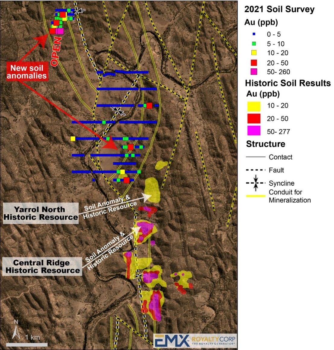
EMX’s 2021 programs at Yarrol included the collection of 544 soil samples, which identified two new gold-in-soil anomalies (see Figure 3). The northern anomaly, known as the Limestone Creek area, lies approximately five kilometers northwest of the historical Yarrol gold resources. This new anomaly has dimensions of 200 by 600 meters, with the strongest results along the southernmost line. The area was identified as a target by EMX on the basis of magnetic inversion geophysical models, previous geochemical results and the presence of numerous historical prospecting pits. The Limestone Creek anomaly also coincides with a zone of albite-silica-goethite alteration developed adjacent to a monzonite porphyry and remains open to the south. The anomaly has a scale and tenor that resembles those over the historical gold resources on the Yarrol Project.
Other gold-in-soil anomalies have been delineated immediately northwest of the historical Yarrol resources, along a contact zone between geological formations within folded and faulted sediments, which also merit follow-up exploration.
In the process of carrying out the sampling programs at the Yarrol Project, EMX geologists also noted boulders of dark manganiferous material in several drainages in the northern part of the exploration license. The boulders were traced back to an outcropping stratigraphic horizon of dark, manganiferous material that has the appearance of a conglomeratic unit.
Nine rock chip samples collected from various boulders, float materials and outcrop exposures averaged 1.1% cobalt, 0.15 % nickel and 10.0% manganese, with a high of 1.6% cobalt with 0.25% nickel. EMX considers this to be a significant discovery of additional mineral potential on the Yarrol Project, as previous efforts had strictly focused on Yarrol’s intrusion-related gold mineralization. Additional sampling programs are underway to better quantify the extent of this unit and its degrees of enrichment in cobalt, nickel and manganese. Barium is also enriched in this material, with eight of the nine samples submitted for analysis exceeding the upper analytical limit of 1% barium.
Note: The nearby mines and deposits discussed in this news release provide context for the projects, which occur in a similar geologic setting, but this is not necessarily indicative that the projects host similar mineralization.
Maps
 Click to Enlarge
Photos
©2024 EMX Royalty Corp. All rights reserved. | Website by Adnet | Privacy Policy | Web Accessibility Policy