
Oijarvi
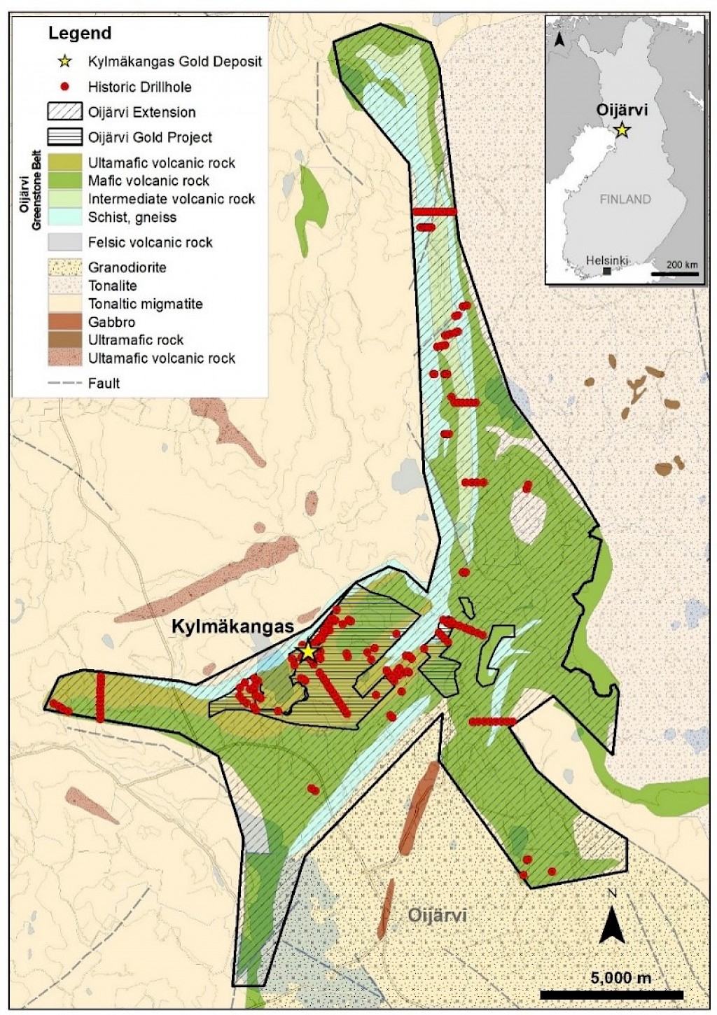
The Oijärvi Gold Project is a 1,641 hectare advanced exploration project located approximately 350 kilometers (km) south of Agnico’s Kittilä Mine and 85 km east of the city of Kemi, Finland. The project is located within an Archean-age greenstone belt (known as the Oijärvi Greenstone Belt), very similar to those found elsewhere in Finland and in the Canadian Shield. The project contains several zones of gold mineralization highlighted by the drill-defined Kylmäkangas deposit, with its historical inferred mineral resource. The Kylmäkangas zone remains open at depth and along strike towards the southwest and northeast, and there is evidence of other parallel gold mineralized trends elsewhere on the project.
Extensions of the Oijärvi Greenstone Belt. The Oijärvi Greenstone Belt extends for a further 20 kilometers northeast of Kylmäkangas, and a further five kilometers to the southwest. EMX and Gold Line believe the entirety of this belt to be highly prospective for further discoveries. Notably, reconnaissance drilling 1.8 km to the southwest of the Kylmäkangas deposit also intersected gold mineralization in the same stratigraphic position as Kylmäkangas with little to no drilling in between. This same stratigraphic horizon remains untested further to the southwest within the Oijärvi Extension Property.
Together with the Oijärvi Gold Project and the newly acquired Oijärvi Extension Property, Gold Line now wholly controls an emerging gold belt in Finland, with EMX strengthening its position as both a strategic shareholder in Gold Line and royalty holder on the assets. EMX will continue to assist with advancement of the projects in its technical advisory role with Gold Line.
Comments on Historical Drill Results and Resource Estimate, and Nearby Mines and Deposits. EMX has not performed sufficient work to verify the projects’ historical drill results and the Kylmäkangas historical resource estimate, but considers this information as reliable and relevant based upon independent field review, including inspection and resampling of historical drill core. Agnico’s Kylmäkangas Au-Ag historical resource estimate was based upon: angle core drilling and fire assaying of half-core samples, a 3D model of the geologic controls (e.g., shear-hosted steeply dipping quartz veining and brecciation) to the Au-Ag mineralization based upon reconciled interpretations on section and plan, inverse distance squared interpolation with controls to assay outliers that included grade capping, and reporting based upon a 2 g/t cutoff grade.
Note: The nearby mines and deposits discussed in this news release provide context for the projects, which occur in a similar geologic setting, but this is not necessarily indicative that the projects host similar mineralization.
Maps
 Click to Enlarge
Photos
©2024 EMX Royalty Corp. All rights reserved. | Website by Adnet | Privacy Policy | Web Accessibility Policy